Web Cams
Stats
Welcome to SouthForkRiver.Net!
Southforkriver.net is named after the South Fork of the Tuolumne River in the Central Sierra Nevada Mountains. It is where we have spent most of our life vacationing and enjoying the outdoors and mountains. The South Fork of the Tuolumne River starts in Yosemite National Park and flows downhill until it merges with the main fork of the Tuolumne River at the bottom of the Rim of the World. Prior to joining the main fork it merges with the Middle Fork in the canyon just down from Rainbow Pool.
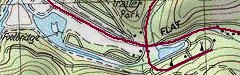
The headwaters of the river start just above the Tioga Pass Road (Highway 120) in the park at an elevation of about 8,750 feet. It drops under the road and then continues to flow through the backcountry of the park until it exits the park at Carlon. Carlon used to be the main entrance to the park where it lead through Aspen Valley, but now the main road enters the park at the Big Oak Flat Entrance. The river continues to flow downstream and crosses Highway 120 again at Italian Bar just above the town of Hardin Flat. It flows through Berkeley Camp and Hardin Flat before taking its course through the rugged backcountry canyon on it's decent to Rainbow Pool.
Rainbow Pool is just off of Highway 120 at the bottom of Sawmill Mountain at the large green bridge. Rainbow Pool used to be the Cliff House, named after the resort and lodge that stood there in several forms for many years. It is a favorite swimming hole in the summer and is noted for its waterfall slide, cave behind the falls and the cliffs to dive from. From Rainbow Pool the Southfork drops quickly down the Slide where it meets the Middle Fork and then to the bottom of the canyon near Lumsden Bridge where it meets the main fork of the Tuolumne River. More…
More about Southforkriver.net
This site contains pages for the cabin reservation system, backpacking trips, photo albums and Sue's sewing projects. Click on the respective pages above to see what's available.
I ran across this old newsletter written by Rosa Guinn about the Hardin Flat Road history. This newsletter is about Berkeley Tuolumne Camp. I thought I would share with you all. It is about 9 MB file size so beware.
If you are interested in the High Sierra's and Backpacking, please visit High Sierra Topix

Tuolumne River Map
If you would like see a larger map of the Tuolumne River or download one, click the link below.
Weather
Weather Widget