2005 Backpacking Trip - Tuolumne Meadows to Yosemite
| Introduction |
| Day 1 |
| Day 2 |
| Day 3 | Photo Album |
| Map | NG Topo Map |
Introduction
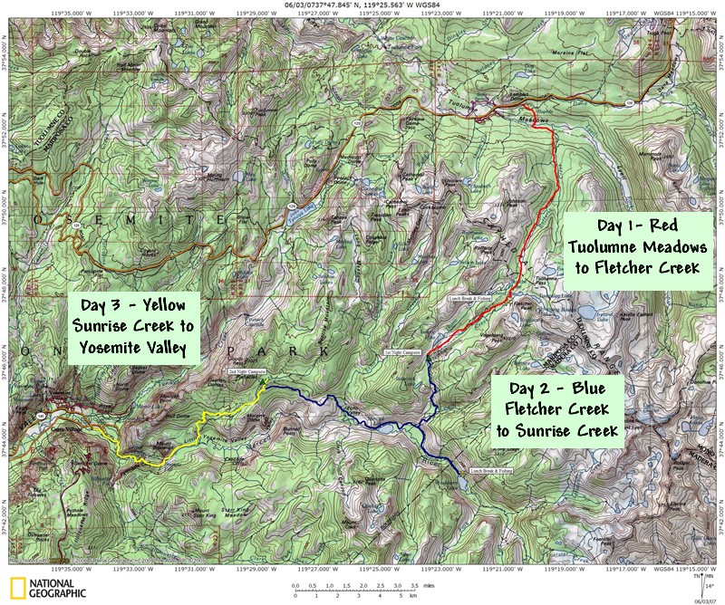
This journal describes the backpacking trip my brother Mike and I took in the summer of 2005. A map of our trip can be seen by clicking on the link above or you can download a NG Topo copy of the map if you have National Geographic's Topo software. We left in late June from Tuolumne Meadows and headed southwest to Yosemite Valley. It was a three day-two night trip that is typical for this area. I had not backpacked in many years and this was the first time in a very long time with my brother. The last time I went was with my son on a failed attempt to reach the Hogback on the Middle Fork of the Tuolumne River out of Evergreen. It failed because we could not find the usual starting location as the roads had changed when the fires went through the area several years before. We finally found the trail and were met with a rather large rattlesnake. As the years go by and the story gets told again and again, I swear that snake gets bigger and bigger! But we gave up the trip after our encounter with the buzztail and made it back to the comfort of the cabin. I had not been able to convince my son to try again and figured backpacking was done for me. To my surprise, Mike called me up and convinced me to head out with him to do some fishing in the backcountry.
The preparation for the trip included buying some new equipment, such as a new pack (Go-Lite Speed) and some miscellaneous equipment but nothing too drastic (that would come later believe me!). I also spent a lot of time trying to get into shape by taking a lot of walks and day hikes as well as doing a lot of swimming. I'm glad I did because the hike had some serious pulls up the hills. As the months got closer I starting feeling like I was in decent enough shape and the packing and organizing began. The winter of 2004 and 2005 was a very heavy snowfall year. Our original plans for the trip were to head out of Lake Mary near Mammoth and hike towards Lake Virginia and Duck Lake. But the snow was too heavy and we made contingency plans to hike out of the lower elevations of the park. Tioga Pass did not open until mid-June that year and our trip was booked for the end of June. So a trip from Tuolumne Meadows to the Valley seemed in order.
Weather
Las Vegas, NV
Sawmill Mountain
Groveland, CA
Yosemite Natl Park
.Clearlake, CA